Why I Kayaked the Entire Charles River
After hundreds of years, dams along the Charles River could come down to let the currents run wild and free—and help the environment. To get a closer look, our intrepid river rat set out to become the second person ever to kayak the iconic waterway's complete length.
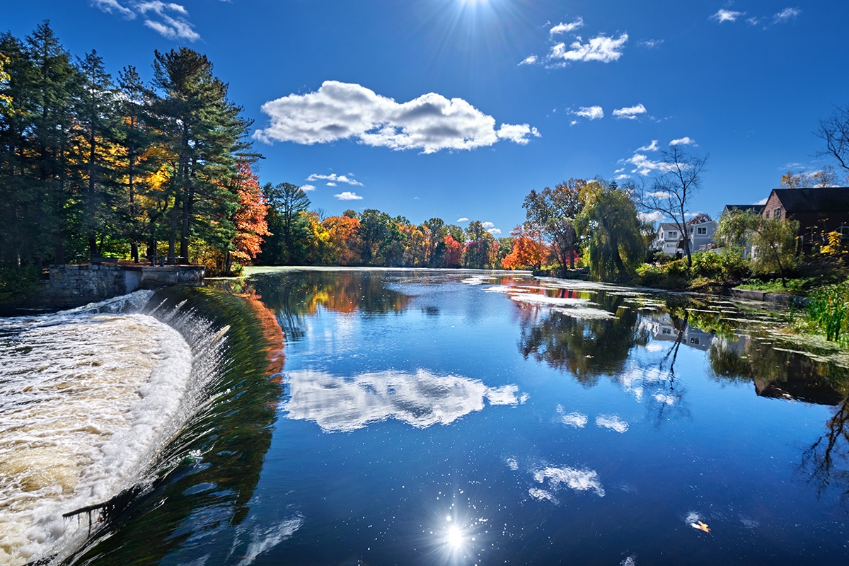
The Charles River at South Natick Dam Park / Photo by Getty Images
At dawn, fog rose from the surface of the Charles River. On that morning last autumn, songbirds darted over the water as I kayaked downstream through a wide channel lined by maples and oaks in the suburban semi-wilderness of Millis, Medfield, and Dover. The presence of people seemed faint, almost primitive. The river twisted through S-turns, the current silent but strong under my boat, pushing me along. The world felt wild.
As soon as I reached Natick, though, everything changed. I found myself in a pond 100 yards across as civilization sang out from both shores. There were gracious mini mansions all around me now, not to mention elaborate docks and bright green lawns. Scores of white swans floated about as though hired by Central Casting to increase the serenity factor.
This radical shift in both vibe and appearance along the river occurred because the South Natick Dam—a wide, 135-foot-long earthen berm built in 1934 and now topped by pine trees—was just ahead of me. It choked and reshaped—indeed, tamed—the river, creating a pond and a gentle waterfall burbling over its concrete spillway.
The pond and waterfall are the centerpiece of the South Natick Dam Park, arguably one of the loveliest and most iconic—and Instagrammable—spots on the Charles. And it will soon be no more. The dam has long been in bad shape, and the town of Natick faced a choice: either spend $2.6 million to shore it up or $1.5 million to tear it down. In late 2022, after a pitched battle among residents, the Select Board voted 4 to 1 to remove the dam.
The lower price tag for removal was just part of the decision, though. Dam removal provides significant benefits for the natural environment. When the South Natick Dam comes down, for instance, long-trapped fish, unable to navigate upstream because of the dam, will resume their old patterns of migration, and ospreys and eagles will again descend on the river to feed on them.
That likely will be only a foretaste of a newly wild Charles River. A group called the Charles River Watershed Association (CRWA) is pushing to get every dam that does not serve a purpose along the 80-mile-long waterway removed in the coming decades. The CRWA yearns to make the Charles a rare thing—a city river that flows freely along most of its course.
With the onset of extreme rainstorms caused by climate change, the plan carries urgency—not just for wildlife but for humans, too. Dams break under strain, as they did in Libya last September, killing more than 4,000 people. That’s an extreme example, but destruction on the Charles is still a real possibility. As of early 2022, the Department of Conservation and Recreation (DCR) rated the South Natick Dam as being in poor condition and notes that it is a “high hazard dam” because it’s “located where failure will likely cause loss of life and serious damage” to homes, businesses, and roads. Four other dams on the Charles are likewise rated as being in poor condition, and two are a notch worse, rated as “unsafe.” According to the CRWA’s executive director, Emily Norton, “People are waking up to the dangers dams pose. That’s why I think this plan will catch on.”
Undamming the whole Charles is still more of a green dream than a firm plan. It could be several years before the South Natick Dam comes down, and even Norton doubts the scheme to free the entire Charles will be a reality in fewer than 20 years. But hearing about this potential shift was enough to get me excited. Some people want to see Antarctica before it melts away; I felt a desire to see the Charles before its dams are torn away. I wanted to know what hints of natural splendor still exist on the Charles, even now, amid all the dams. And I wanted to see where the river is most hindered by humans.
I had, in other words, the perfect excuse for an adventure, and for me, there is nothing more gratifying than throwing myself into a place that I don’t know and then endeavoring to learn its story by working my muscles and facing down a sliver of danger. Over the years, I have ridden my bike across a swath of the Mongolian steppe to visit the towering statue of Genghis Khan, and also kayaked nearly the whole 51-mile length of the Los Angeles River. I did this in part because it’s my belief that our current environmental crises—climate change, species die-off, water pollution—are rooted partially in our alienation from nature. We keep it at a distance. We’re afraid of it, and I don’t think we should be.
I also like undertaking adventures that others haven’t. As far as I could tell, only one person has ever kayaked the entire length of the Charles: Cameron Salvatore, an art director from Watertown, who did it in 2020. So one morning last September, when the Charles was running high and fast, I lashed my kayak to my car’s roof and made my way to the headwaters, hoping to become only the second person ever to paddle the Charles from its uppermost reaches to the sea.
The source of the Charles River is a reservoir called Echo Lake in Hopkinton. Kayaking there is not permitted, so I began looking for a place to start just downstream from the dam forming the reservoir. The Charles that I encountered there, on the side of a bike path, was a mucky little trickle, ankle-deep and maybe 2 feet wide as it flowed through a swamp. In 2020, when Salvatore paddled the river source-to-sea, he assiduously made it through the section by using his paddle to push himself through the muck.
I was not eager for such an onerous abs workout, so I began my adventure on the Charles around River Mile 5 in suburban Milford. Specifically, I embarked on my voyage inside a concrete culvert a few hundred feet long that was carved beneath the town in 1939, when city planners still believed that a natural feature like a river, inherently impetuous and irregular, could be brought into compliance with society’s paved, rectilinear world.
When I emerged into the sunlight from the tunnel, the concrete civilization fell away. Suddenly, I was in a raging little stream, coursing along through scrubby woodlands and over downed trees caught in the river. Ahead of me, great blue herons glided over the water.
When the Pilgrims founded Boston in 1630, the Charles River looked even more undisturbed than this. It was a tide-tugged flow that met the sea in Watertown, which today is 9 miles from the nearest salt water, which lies in Boston Harbor. The Nipmuc, the Wampanoag, and the Massachusett Native Americans fished from its waters for their own consumption; they also used the fish to fertilize their crops. For a long time, Europeans, too, found sustenance in the Charles. In 1850, an estimated 9 million rainbow smelt were harvested from the river.
The Charles began taking a new course in 1634, when entrepreneur Thomas Mayhew erected a small stone dam in Watertown to power a grist mill, making the river one of the first in the country to be dammed. Over the centuries that followed, many more dams went up on the Charles to drive corn mills and sawmills and, later, to power textile mills. The 19 dams now on the Charles constitute a vestigial machine-age straitjacket. None of them has a current industrial purpose (though some provide flood control or serve as water supply dams), and most are ancient, making them porous or prone to breaching. They remain in place, though, blocking the flow of fish upriver and turning the Charles into a very unnatural—but often pretty—medley of small lakes.
The 19 dams now on the Charles constitute a vestigial machine-age straitjacket. None of them has a current industrial purpose, and most are ancient making them porous or prone to breaching.
Dams are not the only manmade obstacles along the Charles. Seven miles into my journey, in Bellingham, I reached the spot where the river funnels into an underpass beneath Interstate 495. Would there be enough clearance for me with the water running high? In the days before I paddled, I lost sleep over that question. One morning, while driving, I pulled to the side of 495. As cars hissed by, I got out with my measuring tape. The tunnel, I learned, offered but 10 inches of clearance. I did some calculations: Would it be possible to keep my nose above water in the darkness as I pulled the kayak beneath six lanes of traffic? And, more to the point, would I die down there?
I opted for a car portage that involved a little planning. Before I set out, I locked a bike to a post near where I would get out of the river. When I got there, I stashed my kayak in the woods, retrieved the bike, and rode it back to where I started and got my car. Then I put my kayak on my car to get over 495, dumped my car in a nearby parking lot, and got back in the river.
I paddled about a mile until I came upon the remnants of the Caryville Dam, the very first dam on the Charles that has been deliberately removed. It was once the centerpiece of a thriving little village with its own grist mill, cotton mill, and shoe factory. By the mid-20th century, the structure was no longer used, causing it to fall into disrepair. In 2016, it came down.
I reached an intact dam just 20 minutes later when I paddled up to the decrepit West Medway Dam, deemed to be in poor condition by a 2023 DCR study. Sitting beside the old stone remnants of a ruined mill, the dam had trees jutting out of its cracked concrete, and they stood sentinel over a partially collapsed concrete wall that frothing water rushed over. Even a ravaged old dam alters a river’s flow, though. After I portaged over the dam and put my boat back in the water, the river was roiling, its channel narrowed so the current sprang as hose water does when you constrict the flow with your thumb. Suddenly, I encountered lots of boulders and found myself bouncing along through foamy white rapids, my pulse thumping hard in my throat.
In the fast-moving water, I slammed into a log spanning the river. Pinned, my kayak spun sideways. The current gushed into the boat, slowly submerging it. I grabbed onto the log and realized that if I did nothing, it would only be a matter of time before my grip weakened and I got sucked underwater and possibly trapped under the log. I dropped my paddle so I could use both arms to pry myself up onto the log. It was slow-motion work. Pressed by the current, my legs were dead weights—1,000-pound rocks I had to lift skyward. Still, I managed to wrench my way up to safety on top of the log. Then I watched in horror as my paddle floated downstream, and I asked myself why I’d been stupid enough to embark on this solo seat-of-the-pants Charles River expedition.
At least, I thought, I could still salvage my half-submerged kayak. I pulled it under the log. Then I grabbed the bow and frog-kicked the boat toward shore. Miraculously, I found my paddle waiting for me, its progress cut short by a fallen branch. It was a stroke of good luck, but I was pretty spooked and began to worry I wouldn’t survive the rest of the journey.
Twenty minutes after getting back on the river, I received my second immersive lesson in dam hydrology when I capsized again after the Medway Dam. I was able to get back into my kayak fairly easily, but my trip was not exactly going swimmingly. I was exhausted, and my sleeping bag was soaking wet.
After a couple more hours of paddling, I tied up my kayak, wrung out my bag, and carried it 2 miles into Millis to get some lemon chicken with rice at a Chinese takeout joint. I ate it in a nearby laundromat as my bag tumbled dry. When the timer went off, I caught an Uber back to the river’s edge and found a flat place in the woods to bed down. Exhausted, I slept like a rock.
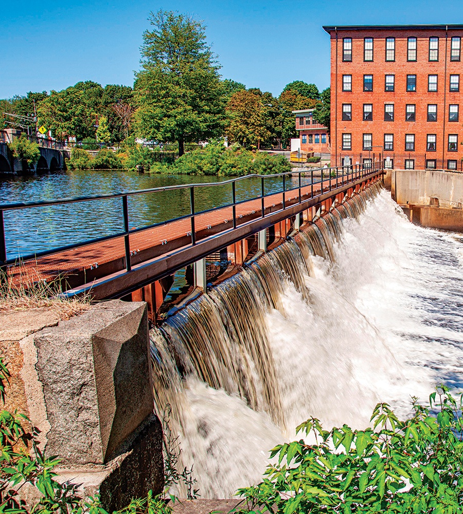
The Moody Street Dam in Waltham / Photo by Norman Eggert/Alamy Stock Photo
I woke just before dawn and felt my way through the dark to the river’s edge. Moments after I climbed into my kayak, in the day’s first light, I saw a large-antlered deer swimming in the river right in front of me. Deer are abundant in suburbia, certainly, but I felt lucky to be communing with this one on such a lovely morning. I could just as easily have been inside, staring at a screen, or stuck in one of the traffic jams gathering on the highways nearby.
I saw other wildlife on my trip. In Needham, a large white bird, a great egret, flew straight toward me and landed right near my boat, its feet skimming the water, kicking up a tiny wake. I watched as it dove underwater, looking for fish. It emerged and flew for 100 or so yards, just inches over the water, eyes down as it continued to hunt. On the Cutler Park Reservation, a square mile of preserved marshland, I saw a less common snowy egret—smaller, with a slender black bill—perched in a tree.
Still, civilization and its ugliness were at hand my whole way down the Charles. Early on, when the river was narrow, I saw three discarded lawn chairs lying in the water, up against a clump of fallen sticks. Now, for a few miles, I paddled within earshot of I-95, the giant green highway signs visible from the river.
In the 1800s, the human stain upon the river was a lot worse. The Pilgrims and their descendants flushed the city’s sewage straight into the Charles—so bountifully, in fact, that on summer days, a ghastly smell pervaded the streets. By 1879, water pollution was such a concern that Boston enacted a “Sanitary Improvement” plan, creating the Fens, a restored salt marsh in the Back Bay, to absorb flood waters and sewage.
That helped some, but then, in 1910, the construction of the Charles River Dam at the mouth of Boston Harbor—built to control floods—made it worse. By eliminating the tidal flushing of the river, it trapped all effluents, including sewage, in Greater Boston. The Charles eventually became a national embarrassment and the subject of the 1966 hit song “Dirty Water.”
These days, thanks to the Deer Island Wastewater Treatment Plant, the Charles is only invaded with sewage after heavy rains. Freeing the river of dams wouldn’t erase the river’s rainy-day problems, but it would certainly improve things, says U.S. Environmental Protection Agency spokesman Tom Faber. “Dam removals can improve water quality by lowering stream water temperature, increasing dissolved oxygen, and reducing the time that water stays in the river,” he says, adding that the free-flowing water makes algal blooms less likely to form.
The CRWA hasn’t definitively named every dam it wants on the chopping block, but right now, it’s sparing at least five of them, including the Echo Lake Dam, the one enclosing the reservoir in Hopkinton; the Moody Street Dam in Waltham, which controls floods; and the New Charles River Dam, completed in 1978 at the edge of Boston Harbor to protect the city from flooding.
As I continued my voyage, I neared two major dams, and there was no way I was going to paddle them. The first, the Silk Mill Dam in Newton, boasts a roaring 15-foot-high waterfall. I portaged this one, dragging my kayak up and down a long, steep hill. I was weary now, sunburnt and dehydrated, with crosshatched cuts on my shins from the riverside brambles. My shoulders and upper back were aching.
Still, I paddled on, heading toward the fully breached Bemis Dam, which has Class 1 rapids after it. Built in 1778, it powered a paper mill and, later, a cotton mill that in 1807 manufactured the sails for “Old Ironsides,” a.k.a. the USS Constitution. As I approached the dam, I was exceedingly fearful of capsizing a third time, in the dark. My plan was to take out the moment I heard the dam’s rapids, portage around them, and then make a final late-night surge to the harbor in Boston.
Before I reached the dam, though, I butted up against a downed log, which spun my boat backward for a second, so it pointed upriver. It scared me so badly that I decided to call it a night. I laid my sleeping bag down in the brush by the bike path in Newton and slept fitfully, shivering a little, until 3:30 a.m. Then, vaguely rejuvenated and eager to move and get warm, I pushed on.
After an hour, I neared the Watertown Dam, which likely will be the next to come down after the South Natick Dam. The city council is in support of its removal, and the DCR, which owns the dam, deems it a “significant hazard dam” in “fair” condition. It will soon launch a study to evaluate the impacts of removing it.
The portage around the dam was easy, and I reached the wide, flat waters of Cambridge before dawn, just as half a dozen competitive rowing squads were warming up, each one trailed by a coach riding an electric boat as he intoned instructions from a microphone. It was surreal being in traffic after such a long and mostly solitary journey, especially given how much smaller and slower my craft was than the rowers’. I felt like a traveler from another time, especially when, near Mount Auburn Cemetery, I was accosted by a microphoned coach voice. “I would encourage you,” the voice said, “to get on the correct side of the river.”
This was the voice of decorum, of civilization. But did Coach know that he was plying a 14,000-year-old river that has only been dammed and tamed within the past 400 years? Was he cognizant that a wild Charles River still lives, stifled a bit, amid the dams and the highway bridges of the 21st century?
If the dams go down, the old Charles will spring back. The fish will return. The birds will follow them.
As I labored under the Longfellow Bridge, the towering offices of Cambridge to one side of me, the golden dome and Boston skyline to the other, I thought about how downtown Boston may never see the full force of that river again. The New Charles River Dam will remain; the tides will never flow into the city. But upriver, if the dams go down, the old Charles will spring back. The fish will return. The birds will follow them. The river will meander free as it did long ago, and the change, I’d argue, could prove to be a tonic for Greater Boston. It would connect the region to nature and give us a bit of the old Charles River.
I kept paddling all the way to the harbor. By the time my trip came to an end, I’d navigated 75 liquid miles in 47 hours. I’d communed with the river, even as I negotiated the Charles’s concrete obstacle course. The river had beaten me up and terrified me, but it had given me a glimpse of something I’ll never forget: the power that a wild river can carry.
First published in the print edition of the April 2024 issue with the headline, “That Dam Charles.”