

Almost all of Arkansas, including Columbia and neighboring counties and Louisiana parishes, are under a tornado watch until 9 p.m. Friday, April 5, 2025 as a siege of violent spring weather continues.
A flash flood watch also remains in effect through Sunday morning.
Clean-up work continued on Friday along Arkansas 344 and County Road 27, east and south of Lake Columbia, after a possible tornado raked through the area on Wednesday night.
The National Weather Service has not yet posted a storm survey of the damage.
Drone videos provided by the Columbia County Sheriff’s Office show snapped trees and damage to power lines and homes along a path from County Road 27 South, to Arkansas 344, to County Road 33.
CLICK HERE to see drone footage from the Columbia County Sheriff’s Office along County Road 27.
This area includes Antioch West Baptist Church, the Rudd’s Crossing community, CR 53 which leads to Lake Columbia’s South Shore Landing and park, and the Lakeside Water District office.
State and county road crews and Entergy Corporation worked through Thursday and into Friday to clear debris and restore power.
A team from Farmers Bank provided residents and emergency workers with meals from the Antioch West Baptist Church parking lot.
As of 1:30 p.m. Friday, Entergy reported that 208 of its customers remained without service along County Roads 27, 29, 53, 148 and 152. The company hoped to have all power restored by 6 p.m. Friday.
magnoliareporter.com has recorded 1.02 inches of rain since April 1, including 0.68 inches on Thursday. Year-to-date rainfall is 14.57 inches.
The National Weather Service in Shreveport said excessive runoff may result in flooding of rivers, creeks, streams, and other low-lying and flood-prone locations.
Creeks and streams may rise out of their banks. Flooding may occur in poor drainage and urban areas.
Periods of showers and thunderstorms will remain possible today through Saturday night across Northeast Texas, Southeast Oklahoma, and Southwest Arkansas, near a stationary front.
Locally heavy rainfall will be possible, with additional rainfall amounts of three to more than six inches possible with isolated higher amounts. As grounds continue to saturate, these totals may result in flash flooding across the watch area.
Moderate flooding is expected along the Ouachita River at Camden until further notice.
At 8:30 a.m. Friday, the stage at Camden was 19.1 feet. The river is expected to rise above flood stage late tonight and continue rising to 36 feet Thursday afternoon. This crest is based on rainfall forecasts for the next three days.
Flood stage at Camden is 26 feet. At 36 feet, moderate flooding begins. Access roads to commercial, industrial, and residential developments will be flooded. Access to locations along the river downstream of Camden will be by boat only.
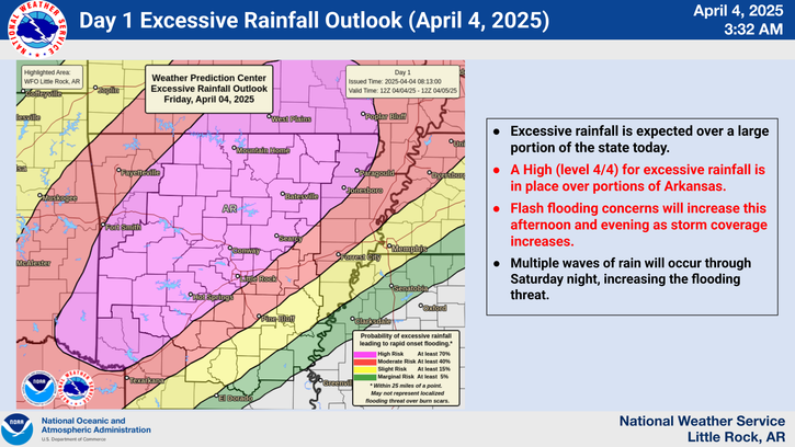
The National Storm Prediction Center said a life-threatening, catastrophic, and potentially historic flash flood event continues across the Lower Ohio Valley and Mid-South to Lower Mississippi Valley.
Additional episodes of significant severe weather expected from the Mid-South west through the Ozarks and Ark-La-Tex with very large hail and strong tornadoes possible.
Several developing waves of low pressure acting on a stalling frontal boundary will continue to be the focus for the threat.
Deep moisture pooling along the front combined with impressive dynamics will set the stage for persistent rounds of intense thunderstorms capable of producing torrential downpours
throughout the region. This will especially be the case into the Mid-South and Lower Mississippi Valley, where the necessary ingredients of moisture, instability, forcing, and wind shear best overlap. Storm initiation and movement roughly parallel to the boundary will lead to repeated rounds of heavy rainfall over the same areas, leading to significant to extreme, potentially historic, rainfall totals over increasingly saturated soils.
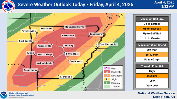
The Storm Prediction Center has issued a moderate risk (level 4/5) for Friday from the Ark-La-Tex into southeast Missouri for strong tornadoes, very large hail, and damaging winds.


